Overview
The TL;DR summary
The city is working to redesign the nearly 40-year old Alewife Linear Park between the Somerville border and the Russell field house. Improvements include:
- a modest widening of the main path to accommodate its modern usage levels, facilitating safer, more comfortable passing interactions between users and bringing it in line with national design standards for shared-use paths
- planting over 120 new trees, plus many other plants and a new Miyawaki forest near Russell Field
- replacing existing dirt desire paths with new stone dust side paths, which will help reduce soil compaction and promote plant growth elsewhere
- adding/upgrading amenities like trash/recycling containers, seating, water fountains/bottle filling stations, emergency call boxes, and natural play features
- drainage and irrigation repair/installation, fixing issues like the large puddles/ice patches that form near the entrance
However, there has been a vocal group (Friends of the Linear Park, or FOLP) opposing these changes, particularly the path widening, calling for the city to "restore not redesign" the park instead. As their campaign includes a lot of misinformation, I decided to do some fact-checking. The main points are summarized in the below table, and if anyone wants to double-check my work, scroll down for the long version.
| Claim | Fact |
|---|---|
| The redesign will "kill or maim" over 100 trees. | The redesign takes care to preserve most of the existing tree canopy, and will greatly expand it with new plantings. Specifically, the plan has only 6 tree removals (5 already in poor condition), and will also plant over 120 new trees. As for "maimed," only ~15 "high risk" (by FOLP's own metrics) trees will actually see increased asphalt encroachment in their root zones. |
| The redesign will double the amount of pavement. | The actual increase in pavement area (asphalt with small sections of brick/concrete) is 13%. "Double" comes from misleadingly classifying stone dust surfaces (shoulders and side paths) as pavement. |
| The existing 10.5' path width is already compliant with AASHTO shared-use path standards. | While that width is technically over the minimum of 10', AASHTO-recommended FHWA grading (which takes path usage into account) gives it a "D" at best, trending towards an "F" with expected future increases in the number of people using the path. |
| The path widening is only to benefit bicycles, to let them go faster and save them 30 seconds. | The widening will improve safety and comfort for all users, by providing more room for passing interactions between various users moving at different speeds along the path. |
| The current path matches the width of the nearby Somerville and Belmont community paths, so widening is unnecessary. | The original section of the Somerville Community Path is typically 12'-14' wide, and the new 10' wide budget-cut version of the extension is already too narrow/congested. Linear Park also sees much higher usage than the SCP. The latest design for the planned Belmont community path is 12' wide. |
| There are alternative routes available for cyclists and they should be diverted there instead of using the path. | The existing/planned "sharrows" on Dudley and Harvey streets are a poor substitute for an off-street route like the Linear Park path. Additionally, cyclists cannot connect to Mass Ave via Dudley St as the last block is the wrong direction. |
Let City Council know you support the redesign of Linear Park!
The Neighborhood & Long Term Planning committee will be discussing the Linear Park project tomorrow (Tuesday) Nov. 14 at 12:30 (city calendar link, open meeting portal link).
If you are able, please consider:
- Signing up to give public comment. Unfortunately the hearing is in the middle of the day, but there is a remote/Zoom option if you've got a few minutes to spare during your lunch break.
- Emailing City Council (council@cambridgema.gov), or if you prefer, just the committee members (Carlone, Nolan, Zondervan, McGovern, Mallon - contact info here), to express your support for the city's redesign plans and push back on the misleading claims being circulated.
- If you'd like your email to appear in the official meeting agenda, send it by midnight before the meeting and cc the City Clerk (cityclerk@cambridgema.gov). Also consider cc'ing the City Manager (citymanager@cambridgema.gov) as he's the actual final decision maker here.
Background
About the park
The Alewife Linear Park was opened in 1985 as part of the extension of the Red Line to Alewife. The park roughly sits atop the Red Line subway tunnel between Alewife and Davis stations and is a popular spot for neighboring residents to enjoy nature, walk their dogs, or go for a jog/run.
It also serves as a critical off-street link for people walking, rolling, and cycling between Alewife and the Mass Ave corridor, as well as further on to Davis Square in Somerville. Zooming out, Linear Park is a key piece of the larger regional greenway/shared-use path network, connecting people arriving from the Minuteman Bikeway and the forthcoming Belmont Community Path to the recently extended Somerville Community Path which can take them almost all the way to Boston.
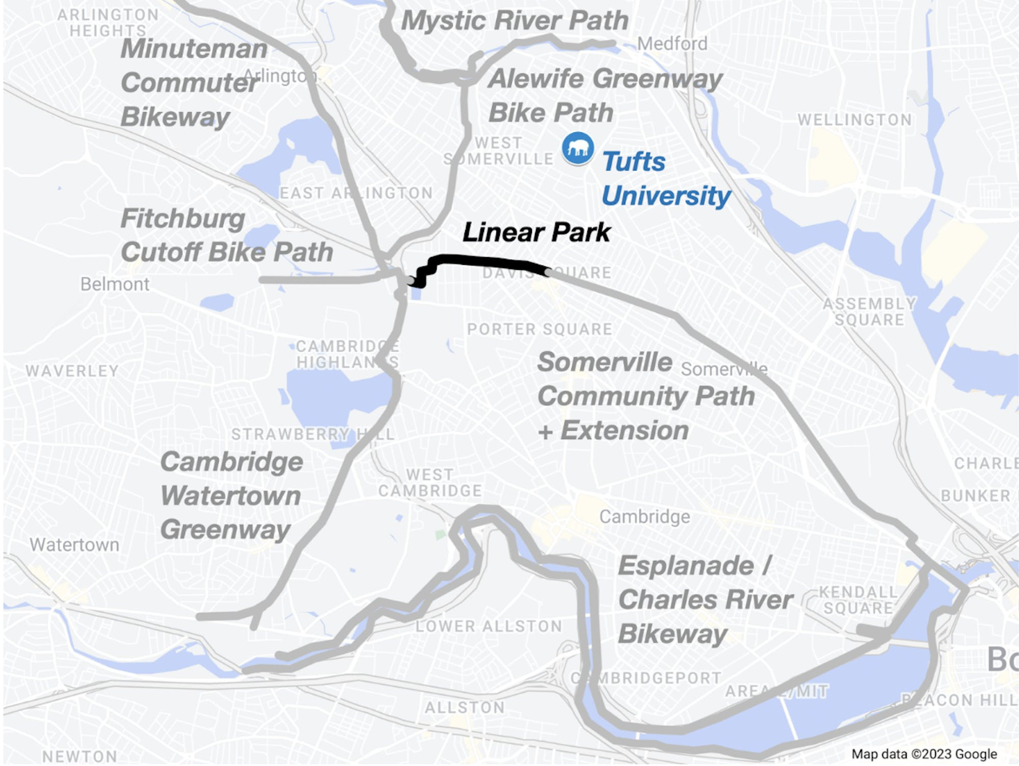
Redesign project
Now, several decades later, the city of Cambridge is working to redesign the park between the Somerville border and the Russell field house, both making much-needed infrastructure repairs as well as taking the opportunity to improve the path experience for all users. This includes:
- drainage and irrigation repair/installation, which will fix issues like the large puddles/ice patches that regularly form near the path entrance
- a modest widening of the main path, facilitating safer passing interactions and bringing the path in line with nationally-accepted shared use path standards that accommodate its high traffic and wide variety of users
- putting in stone dust side paths, often replacing existing dirt desire paths, which will help focus foot traffic in a planned way to reduce soil compaction and promote plant growth elsewhere
- adding/upgrading amenities like trash/recycling containers, seating, water fountains/bottle filling stations, emergency call boxes, and natural play features
- planting over 100 new trees and a variety of other ground cover plants, as well as a new Miyawaki forest near Russell Field
More details can be found on the project webpage.

Public engagement on the project began in 2022 and has included surveys (receiving over 600 responses and yielding over 2,000 open-ended comments), multiple presentations and meetings with open public comment, community site walks, nearby open houses, and on-site tabling events. The advanced design was presented June 2023.
Another open house is planned before the end of this year, and the final design is expected to be made public and put out to bid January 2024.[1]
Opposition to the redesign
As with any change, not everyone is on board, and in this case there has been fierce opposition from a group called Friends of the Linear Park (FOLP).[2] Their main objection is to the widening of the path, currently mostly 10-12 feet wide with dirt shoulders, to 14' (narrowing to 12' in some sections to accommodate mature trees) with 2' stone dust shoulders. FOLP claims this widening will destroy much of the park's tree canopy and convert the path into a dangerous bicycle "expressway," a term intended to evoke the destructive urban highway projects of the past, particularly the 8-lane Inner Belt that once threatened Cambridge.[3]
Below is a table from the FOLP webpage summarizing their arguments against the redesign. However, many of these claims are highly exaggerated and/or misleading, and the goal of this article is to fact-check these in more detail.
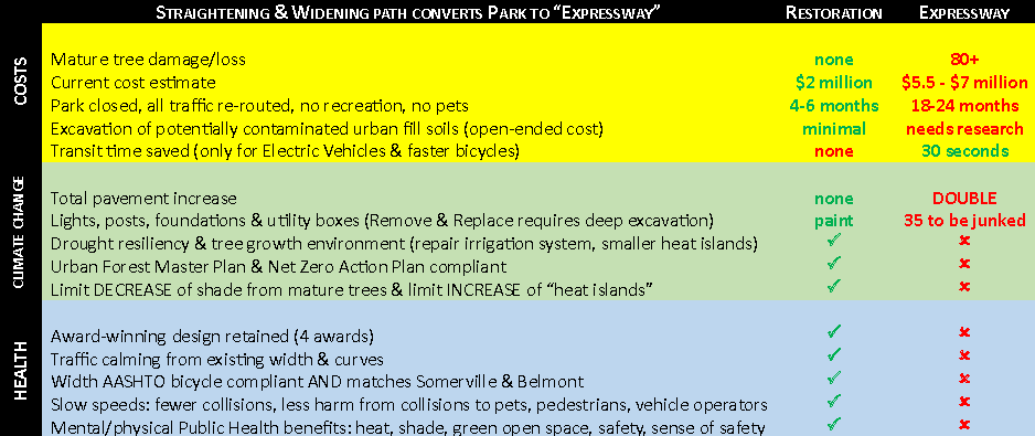
Unfortunately, their campaign has had some success, as the Cambridge City Council recently passed a policy order that uncritically repeats many of FOLP's claims almost verbatim, and requests that the city cancel the redesign and instead do a minimal "restoration" in its stead that will keep the path at its current width. Here is the first order in said PO:
ORDERED: That the City Manager be and hereby is requested to work with DPW to restore[4] Linear Park by re-using the existing award-winning design, including retaining the existing pavement footprint, or consider making the entire path non-pavement as some other multi-use paths are, and using wood chips/mulch instead of stone dust to provide extra space for pedestrians, with the top priority being to extend the life of all existing trees using all best practices;
However, the PO was also referred to the Neighborhood and Long Term Planning committee for further discussion, so there's still a chance to push back on the misinformation and voice support for the redesign!
First, some opinions…
As someone who both walks and bikes on the path, I believe the redesign put forth by the city does a pretty good job of balancing the park's dual roles as a critical transportation link and a valued neighborhood green space. It will be a great improvement for all path users, regardless of mode, while preserving its natural woodland character.
There's been much talk about the awards won by the existing design, and certainly no one is disputing that Linear Park is a beautiful place, but these awards do not make the design untouchable or infallible. The original designers could not have predicted all the ways the park is used today, over a third of a century after its opening. They almost certainly did not foresee that someday, hundreds of cyclists would pass through on the daily; after all, the park predates even the Minuteman Rail Trail!
A redesign does not automatically equal criticizing or disrespecting the original architects, and it is possible to update the path to meet changing needs while still honoring the original architect's intent to "create depth and varied experiences within a very limited Right-Of-Way (ROW) width" and "provide some respite and a break from Cambridge's busy sidewalks."[5]
Finally: while I'm about to be very critical of how FOLP has been playing fast and loose with the facts when it comes to the the park redesign, I fully agree that trees need to be protected where possible. And given recent incidents[6], it is understandable why some people are skeptical of the city's ability to adhere to the Urban Forest Master Plan. I do hope the Committee on Public Planting's comments about irrigation and maintenance are taken into account, to make sure the existing trees as well as the 100+ new trees that will be planted as part of the redesign will all thrive.
With that out of the way, let's do some fact-checking!
Claim: The redesign will "kill or maim" over 100 trees.
I'm starting with this one because it is the crux of the argument against the park redesign.
You may have noticed that the table above says "80+" trees, and this number seems to be what was used in the text of the aforementioned policy order ("could endanger over 80 mature trees"). However, FOLP's numbers have gone up since the table was first published, and their website currently states there are "100+ trees to be removed/maimed JUST by the main path expansion."
I usually find this kind of inconsistency to be a red flag when deciding whether to trust any kind of claim, but let's take a closer look.
The plan only removes 6 trees, 5 of which are in poor condition.
The 5 "poor condition" trees are cherry trees[7] near the Cedar St. end of the park, described in the June 2023 presentation as "hollow, signs of rot and decay." The landscape architect on the project specified that these tree removals are related to their poor health, rather than being specifically due to the redesign or to accommodate the path widening.
The remaining tree on the removal list is a 6" red maple located on a slope that the team would like to transplant if possible, but haven't yet found a site with matching slope to put it.
So, FOLP's "100+ trees to be removed/maimed" actually lumps together these 6 planned tree removals with 90+ "maimed" trees. This alone is pretty disingenuous; most people who read "100+ trees to be removed/maimed" will get a mental image of Linear Park being clear cut by construction workers. No wonder FOLP managed to collect so many signatures for their petition!
But setting that aside for now, let's look at the 90+ "maimed" trees, because if it is true that this many trees are in serious danger from the redesign, that is certainly concerning.
The "killed/maimed" count includes many low-risk trees that would be just fine after treatment.
The basis by which FOLP determined which trees near the path are at risk is how much pavement encroaches on their root zones. They use the "arborist's metric"[8] shown here:

Note: DBH is trunk diameter. Larger trees will have roots that spread further out and should therefore be given a wider berth. So far, all good and reasonable.
FOLP volunteers went through the redesign plans, double-checked all the measurements of tree diameter and location, and identified at-risk trees based on proximity to the redesigned path; definitely an impressive amount of effort. Below is a screenshot from their document summarizing the results of their survey:
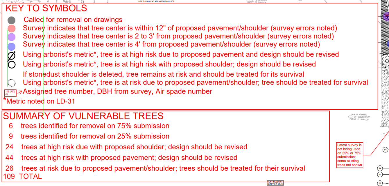
Right off the bat:
- Why are the tree removals from the old/outdated 25% design being counted in the total?
- Why is the stone dust path shoulder considered a risk? Stone dust seems to be an accepted surface material to use around trees, as it allows roots to continue expanding and growing. See this Urban Forestry guide from UF/IFAS extension for an example. In fact, it's being used in some tree wells in Cambridge already, such as these ones in Harvard Square. An intentional stone dust shoulder is also an improvement over the existing unintentional compacted dirt shoulders that turn to mud whenever it rains.
FOLP also identifies a set of lower-risk trees that "should be treated for their survival." Certainly, if there are at-risk trees that would benefit from treatment, the city should definitely do so and update the maintenance plans accordingly. The issue is that this category is being included in the overall "killed or maimed" count.
So, the actual number of trees that would preclude widening the asphalt is 44, by FOLP's own metrics. Still high, but a far cry from the "100+ trees to be removed/maimed" number that is being thrown around in their campaign materials.
Now, let's take a closer look at that set of 44 trees.
Most of the high-risk trees can't actually be blamed on the redesign, but are already that way.
i.e. the redesign does not actually increase the amount of asphalt in these trees' root zones.
First, the "existing award-winning design" already has several trees in constrained locations that are considered "high risk" by FOLP's metrics. Of particular note are the groups of trees located in tree wells in/around the brick-lined path entrance areas by Cedar St. and Cameron Ave.
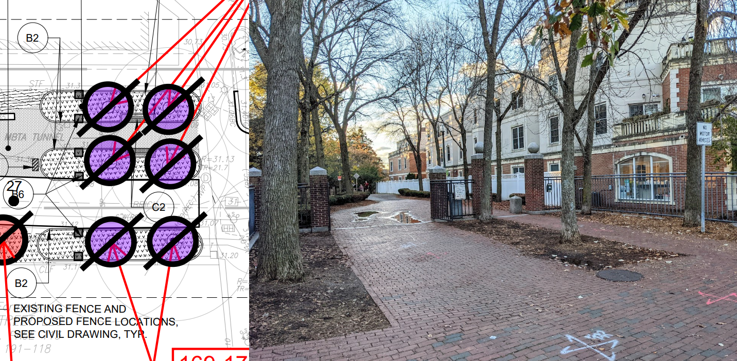
The redesign does not modify the amount of pavement around these trees. Some of the brick may be replaced with asphalt, but the tree wells will not be narrowed in any way. So while these trees may indeed be "at high risk" (though they do seem have done okay so far), it is deceptive to blame this risk on the redesign, and to include these trees in the redesign's casualty count.
Second, the redesign already includes efforts to preserve mature trees. While the overall goal is to bring the path up to standard by increasing the width to 14' where possible, the plans include several 12-foot "pinch points" to give certain mature trees more room. In addition, there are locations where the path does widen, but only the path edge on the opposite side from the tree will be shifted. Below is an example.
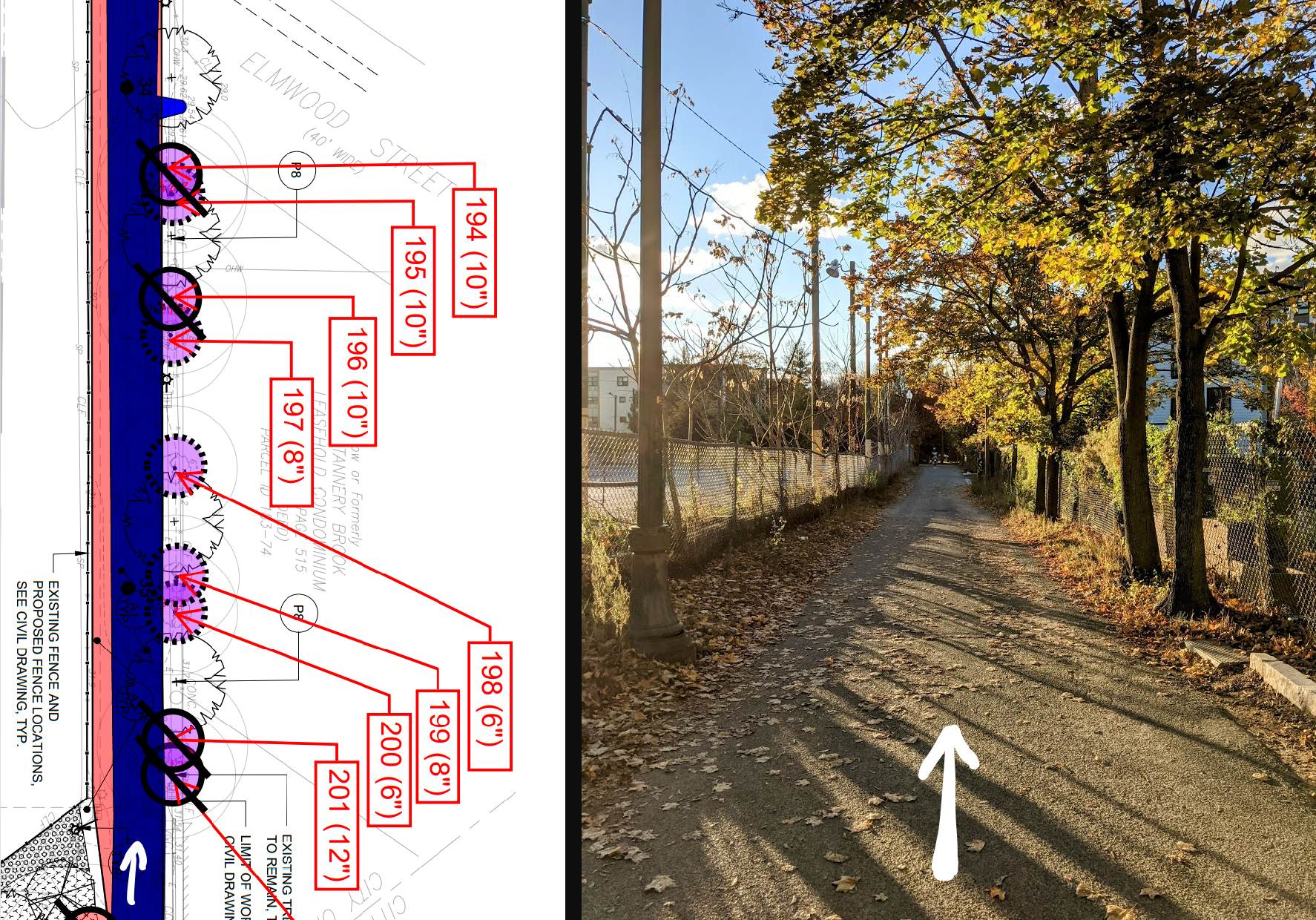
So after taking the group of 44 "high risk" trees and excluding cases like the ones above, the actual number of trees that will see increased pavement in their root zones due to the path widening is around 15, two of which have a diameter of 4" or less.
Trees that are "high risk" by the arborist's metric can and do survive.
Being placed in the "high risk" category is not a death sentence. If it was, the majority of street trees in tree wells throughout the city would be toast! While these trees probably have a tougher life than equivalent ones growing freely in the middle of a forest, there are many examples of them doing just fine regardless. Of course, if any extra care and/or monitoring of these trees is needed during and after park construction, it should definitely be given.
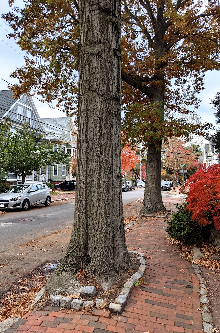
But even if the worst case scenario did come to pass (knock on wood), I believe the loss would be offset by the 120-150 new trees that will be planted throughout the park.
Recently-discovered survey errors are unlikely to significantly change the number of impacted trees.
The most recent development in this saga is that there were some errors in the original surveyed locations of the trees in the park. From a Cambridge Day article published October 18th:
Every place staff checked a surveyor’s work, they were measuring a tree’s distance from the side farthest from the path, "so on paper it made it look like the trees were further away from path than they really were," said Kevin Beuttell, the city’s supervising landscape architect. "We did field measurements to correct those, so those trees are now shown closer."
I am glad the survey errors were caught and expect the project team to adjust the design plans if necessary, but it is unlikely this would drastically change the number of impacted trees. Given the sizes of trees in the park, the type of error mentioned above would alter tree locations by less than a foot in most cases.
Also, assuming the errors were the ones that FOLP brought to the city's attention after discovering them through their own survey (they annotated these as "incorrectly located on survey"): of the trees categorized as "high risk due to pavement," 4 were incorrectly located. However, none of these 4 would actually see changes to the asphalt near them, making the location updates a moot point.
Claim: The redesign will double the pavement area.
As previously mentioned, the most typical condition of the existing path is 10-12 feet wide, and the redesign plans to increase this to 14 feet, with a few 12 ft pinch points. How on earth does that result in double the pavement?
I took the latest October 2023 design plan that was posted on the project page, which shows the new planned path overlaid with the existing path, and converted it to the below graphic contrasting them more clearly. The existing path is shown in blue, and the planned path is shown as a transparent red overlay on top.
As you can see, the changes are actually quite modest. The increase in paved surface area (consisting of asphalt, brick, and concrete) is approximately 13% for the overall project. For the most hotly contested section of the park between Cedar and Harvey, the increase is 15%.
Of course, the design is still not finalized, and there is some margin of error in my estimate due to the fact that the PDF plans have slight overlap from page to page, but there is absolutely zero chance the actual increase will be anywhere near the 100% increase ("double the pavement") claimed by FOLP. So where did this claim come from?
The answer lies in some interesting sleight of hand on FOLP's part. From their webpage:
Why do you say "redesign" doubles (100% increase) the pavement?
The main path now is typically 10.5' wide. The "redesign" with the shoulders varies but is proposed at 18' which is more than a 50% increase. There are numerous "side paths" paved with "stone dust" (compacted on a compacted gravel base) proposed. The various benches and tables will be mounted on concrete pads. Without final drawings, a good estimate is more than a 100% increase in paved area.
So, they are counting "stone dust" surfaces as pavement, which suddenly makes the "paved" main path 18 ft wide instead of 14 ft due to the stone dust shoulders, and also brings the stone dust side paths into the equation. In addition, they are counting the concrete pads for park furniture, which probably doesn't have a huge impact on the numbers but does show the lengths they are going to in order to inflate them.
FOLP's own tree risk analysis (from claim #1) differentiates between trees at risk due to the "proposed [stone dust] shoulder" vs. trees at risk due to the "proposed pavement" (meaning the asphalt portion), so why do they suddenly change their definition of "pavement" and lump in stone dust surfaces together with asphalt?
If you asked anyone in the various depaving movements here and elsewhere what kinds of surfaces they are working to get rid of, it is pretty unlikely that stone dust paths would be on the list. But since debating the definition of "pavement" won't lead anywhere, let's return to the context. FOLP's website says in huge, bold letters up top:
Restoration says NO to city's "expressway" plan with more Black Asphalt, Heat Islands, Dead Trees!
Their campaign repeatedly evokes images of unnatural and ugly expanses of black asphalt like you'd see in parking lots, soaking up the sun and heating up the surrounding air. But light grey stone dust absorbs much less solar radiation, and combined with the fact that the path is already well-shaded (and will see increased shade in the future, as the 100+ newly planted trees grow), a drastic increase in the heat island effect is unlikely despite what FOLP claims.
Also, stone dust comes from crushed rock, making it much closer to dirt than to a petroleum byproduct like asphalt. If FOLP insists on counting stone dust towards the redesign's pavement area, then perhaps they should also include the existing dirt shoulders and desire paths in their equivalent estimates for the existing design.
In addition, the organic alternatives to stone dust that FOLP suggests would make the side paths inaccessible/not ADA-compliant.
Finally, just to throw in a bit of opinion again: I think stone dust blends nicely into a natural setting. Plus, it seems good enough for DCR to use at Walden Pond, some paths along the Charles River, and various other state parks.

Claim: The 10.5' current path width is AASHTO-compliant.
Massachusetts state guidelines say to follow AASHTO (American Association of State Highway and Transportation Officials) recommendations, as set out in their published guides for designing pedestrian and bicycle facilities. The latest AASHTO guidance on the width of shared-use paths is as follows:
The minimum paved width for a two-directional shared use path is 10 ft. Typically, widths range from 10 to 14 ft, with the wider values applicable to areas with high use and/or a wider variety of user groups.
So, 10 feet is the minimum width. And the conditions of high usage/wide variety of users that would require a larger width certainly apply to the Linear Park path.
The AASHTO guide also suggests using the Shared Use Path Level of Service Calculator from the FHWA (Federal Highway Administration) "in determining the appropriate width of a pathway given existing or anticipated user volumes and mixes."[9]
The calculator has corresponding lookup tables for level of service graded on a scale from A-F, for a given trail width and usage levels (users per hour in one direction). It is also dependent on mode split, with increased pedestrian share increasing the recommended path width (which makes sense, as more passing interactions must occur).
I don't have recent pedestrian numbers, but Cambridge publishes bicycle count data online in an interactive viewer here. One of the regular count locations is the intersection of Linear Park and Mass Ave. Quickly filtering for this location ("Cedar St & Massachusetts Ave" in the dropdown menu) and setting the street filter for "Linear Park" yields the following graph of bicycle counts on the path since 2003, split by AM/PM count periods:
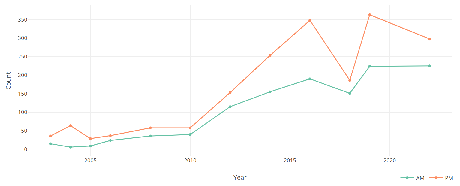
Note: this graph actually underestimates ridership.[10]
Given 2022 peak hour volumes (in one direction) of around ~95 for bicycles alone, and assuming a typical mode split[11], then we are looking at peak hour volumes of between 150 and 200 users. A 10' path under these conditions gets a grade of D or E. And if the mode split is more pedestrian-heavy, which is likely the case for Linear Park, this grade only gets worse.
The AASHTO and FHWA guidance is highly contextual (as it should be!) rather than setting hard cutoffs, so yes, the current 10.5 foot path width technically doesn't "violate" any rules. But surely we should aim higher than a D?
And of course, these are the current numbers, but given the trend seen in the above graph[12] (a boom in ridership over the last decade, though the effects of the recent pandemic on overall commute patterns are still shaking out), bike mode share growing in the overall region, as well as the Belmont Community Path and the nearby large IQHQ development both coming online in the next few years, this number will only go up.
Let's not waste this opportunity to plan ahead and do some future-proofing!
Claim: Path widening is only to let bikes go faster.
FOLP claims that the purpose of the path widening is only to benefit bicycles, to let them go faster and shave 30 seconds off their transit time through the park.
The actual goal of the (again, very modest) widening of the path is to improve safety and comfort for all users. The strongest indication that the current width is too narrow is not cyclists complaining they can't go faster, but rather the many experiences shared by people who have had interactions with bikes that felt unsafe.
While it's important to keep in perspective that serious bicycle-pedestrian crashes are rare, and that cars remain the biggest risk to pedestrian safety (backed up by actual crash data), I can definitely relate to how startling and alarming it is to be unexpectedly passed too closely by a bike, especially as they are pretty silent compared to cars. Having even just an extra foot or two of distance during these passing interactions will make a world of difference for everyone involved.
You don't have to take my word for it, either: the Cambridge Pedestrian Committee strongly supports the city's redesign plans, agreeing that it's "very important to widen the path to ensure that the path can accommodate the ever-increasing number of people using it." And when the Linear Park redesign team asked "What does not work well about Linear Park?" in a survey (which had over 600 respondents giving over 2,000 comments), many people indicated that the park is currently: "crowded, narrow, need more space for different users."
Another issue that's come up is that of high-speed larger motorized vehicles like mopeds and motorcycles using bike lanes/off-street paths. This is something that most cyclists are not happy with either, and are trying to figure out how best to address. But most of the proposed solutions out there (often put forth by people who actually lump cyclists together with these vehicles) amount to "cutting off your nose to spite your face."
For example, one common proposal is putting speed bumps on the path. However, these would create trip hazards for people on foot and pose a barrier for individuals in wheelchairs/other mobility devices. Others have called for a total ban of e-bikes on the path, which would not only be difficult to enforce, but would also harm people who rely on e-bikes to get to destinations further than they would be able to reach without that extra assistance.
Encouraging safe speeds on the path and deterring mopeds/motorcycles is a challenging and multifaceted problem that will require efforts beyond the scope of this project, and perhaps even beyond the city level. But keeping the path at is current too-narrow size is not the answer; though some people[13] seem to hope this will deter specific types of users, all this will lead to is path overcrowding and a worse experience for everybody.
Claim: The current width matches neighboring cities.
FOLP brings up the width of the nearby Somerville and Belmont community paths as additional reasons for why widening is unnecessary.
They repeatedly point to the nearby Somerville Community Path as an example of the current 10.5' path width being sufficient. However, the most heavily used portion of the path, the tree-lined original section between Davis Square and Lowell Street, is actually 12-14ft wide with additional 2-3ft dirt or yellow rubber shoulders on either side. The new section of the path east of Lowell St, which opened with the GLX (Green Line Extension), is narrower/10' wide, not because 10' was determined to sufficient, but as a result of a cost-cutting process to save the GLX project. This process not only reduced the width from the original 12' to 10', but sadly removed many path amenities including various access points and plantings; it is NOT an example worth emulating.
This aerial view shows the stark difference between the old and new sections. Many users of the Community Path extension will tell you that it should have been wider, and that crowding and conflicts between path users increase once you cross over to the new section.
It is also unclear why FOLP mentions the Belmont Community Path as another example of why 10.5' is sufficient, considering that the latest plans (at the 25% design stage) are 12' wide with a 2'-4' shoulder on either side. They are probably thinking of the Fitchburg Cutoff Path that runs between Alewife Station and Brighton St in Belmont, which is unfortunately narrow due to being hemmed in by protected wetland, an active railway, and various private properties, NOT due to 10' being wide enough.
Finally, Linear Park also sees several times more traffic than the Somerville Community Path does, as per bicycle count data from both cities. Even if Somerville and Belmont did find that 10' worked out for them (which again, is not actually the case), that doesn't mean Cambridge should automatically copy them. As discussed above, it is important to size these paths appropriately to their usage levels.
Claim: There's alternative routes cyclists can use instead of the park.
FOLP suggests that cyclists don't actually need to use the Linear Park path because there are viable alternative routes, to which they should be diverted.
While this particular point is not in the above table from FOLP, it's come up a lot in public comments and communications, and FOLP's map locating Linear Park highlights these supposed alternative routes. Several public comments have noted that Dudley St and Harvey St are marked in the Cambridge Bicycle Network Vision as existing or planned "bicycle priority streets."
To be clear about definitions: "bicycle priority streets" are neighborhood streets that are not wide enough to install a protected bike lane, but have low-enough car volumes and/or speeds (or can be made that way using various traffic calming measures) for cyclists to share the road with cars. While these streets are a valuable piece of the overall bicycle network vision, a road with only "sharrows" (not to mention 6 cross streets, many driveways, and parked cars on both sides creating blind spots everywhere) is not an acceptable/equivalent substitute for a separate off-street, car-free path.
Additionally, it is not only the facility type that matters, but its connectivity and routing. Dudley St is the wrong way for the final block to Mass Ave, so cyclists must take a roundabout detour along Cedar St (which has NO bicycle facilities currently, nor any planned in the bicycle network vision - not even sharrows) to reach Harvey or Norris.
That being said, I do think Dudley Street has latent potential to work for cyclists who are comfortable with riding in the middle of the lane/can keep pace with cars, but only after the following changes:
- Add a protected contraflow lane on the last block to Mass Ave.
- Have the gate by the Russell field house be open longer and/or widen the path to Dudley St. When the gate is closed, getting to Dudley involves using narrower paths going around the other side of the field house, with blind spots at each corner.
IF these changes were made, THEN it would be okay to put up signage advertising Dudley St. as a viable alternative to the Linear Park for getting to Mass Ave. I will never say "no" to more options for bicycle routes, and would certainly welcome it if the city decided to explore this as part of setting up construction detours. However, I'm skeptical this could actually happen, as the parking removals required to accommodate such a contraflow lane would likely face strong opposition.
Remaining claims
I didn't address the claims about how much more expensive the redesign is compared to a limited restoration, since I don't know enough about construction logistics to do so. However, given the wildly inflated numbers and rhetorical tricks documented above, I am wary of trusting FOLP's estimates.
And while project plans are always subject to change, especially as the design is not yet finalized, this quote from one of the project leads in a recent (Nov. 8, 2023) Tufts Daily article seems to indicate park construction closures and detours will not be as total/drastic as FOLP is predicting:
According to Beuttell, most of the path will remain open during construction, with safe detours provided for segments that are closed at any given time.
"I think it's highly unlikely that we will close down the entire [path] … I think we'll probably do it in pieces." Beuttell said. "What we're going to try to do is get the work done as quickly and as painlessly as we can. But it's … a little bit of a puzzle to try to figure out how we want to do that."
Finally, while this is more subtle/implied, FOLP's campaign sets up a false dichotomy between bikes and the environment. Please don't buy into this! It is important to preserve and expand the tree canopy, AND improvements to cycling infrastructure are an important part of facilitating mode-shift away from the single-occupancy vehicle usage that is polluting our environment with greenhouse gases, harmful particulates, and noise. The great thing about the redesign is that it advances both goals.
Footnotes
Incidentally, I hope Newport Construction does not bid, or is not selected if they do, given their unauthorized clear-cut of Beacon Street in Somerville during its 2017 reconstruction and subsequent refusal to pay any fines for doing so. ↩
FOLP in turn appears to be a part of another organization called Cambridge4Trees, which is currently headed by Charles Teague. ↩
This is not just subtext! Here is a public comment from John Pitkin (who is currently suing the city to undo the Cycling Safety Ordinance, and who previously sued the city to stop the Inman Square redesign) doing exactly this: "We had another problem with a Community Development Department that was supporting a network of high-speed transportation through Cambridge when there was a great enthusiasm for automobiles in the form of the interstate highway system and the Inner Belt. At that time, the citizens of Cambridge rose up to save Cambridgeport from being devastated by inappropriate transportation infrastructure. I think what we've got on Linear Park is a similar situation. The idea of a high-speed network for bicycles and alternative mobility devices in places where it doesn't fit is something that needs to be reconsidered." ↩
This was amended to a slightly softer "consider restoring" prior to the PO's passage. ↩
Quotes are from a statement by the original architect, posted by FOLP here. ↩
In particular, the irrigation failure in Danehy Park during last summer's drought that led to the loss of several trees, as well as 2 trees in Linear Park mistakenly being cut down by the adjacent IQHQ development due to an incorrectly placed fence. ↩
Someone in the June public meeting asked if these trees could be replaced with new cherry trees, for folks who enjoy the blossoms in the spring. The answer was yes! ↩
Someone during public comments mentioned this metric was from Barrett Tree Service, a well-regarded local tree company with certified arborists. ↩
For those interested, the methodology behind this calculator is explained in FHWA's 2006 report on "Evaluation of Safety, Design, and Operation of Shared-Use Paths". ↩
The graph does not include cyclists turning onto the path from other streets. For example, the most recent data from 2022 shows nearly 100 northbound cyclists on Mass Ave turned left to go onto the path towards Alewife. In addition, these are not all-day counts, but rather are conducted during peak commuting times: roughly 2 hours in the morning and 2 hours in the evening. ↩
The FHWA lists "typical mode split" as 55% adult bicyclists, 20% pedestrians, 10% runners, 10% in–line skaters, and 5% child bicyclists. ↩
The sharp dip in 2018 is due to crummy weather on the count date, but even then there were still a few hundred cyclists! ↩
For example, here is what local resident and former city council candidate James Williamson, who seems quite actively involved in the effort against the redesign (and whose dislike of bicyclists and bike lanes can be found all over the Cambridge Day comments section under his pen name "Poor Bono Publico") had to say at the last project meeting: "I'm glad to hear people talking about the bicyclists, not all of them, but enough of them to make it torture – scary – to walk along the paved portion of the path. […] When people in the city staff have talked about North Mass Ave, they’ve talked about removing the median strip would actually create friction in both directions of the vehicles and that would slow down the cars, vehicular traffic along North Mass Ave. This has been something that’s been said for years, why doesn't that same logic apply here? Why don’t you even think about narrowing the path, and then bicyclists will have to slow down because there’ll be friction created between them as they go pass each other in both directions?" ↩